
Have your say: Lougheed Transit Corridor Area Plan & West Ridge Greenway
The Lougheed Transit Corridor Area Plan (LTCAP) will go to Public Hearing on January 20. That will be the last opportunity for residents to provide feedback before the plan will be finalized and approved by Council.
Once the LTCAP has been adopted by Council, it will become part of the Official Community Plan, which means that it’ll be the long-term plan for the Lougheed Transit Corridor.
The plan calls for significant densification along the corridor, and more commercial and mixed-use development, supported by future Bus Rapid Transit along Lougheed Hwy and a more walkable urban environment to improve mobility options, encourage multi-modal transportation (walk/bike & transit), and thus help reduce car dependency. You can find more about the plan on the City’s website.
Here is an image showing the land use plan:
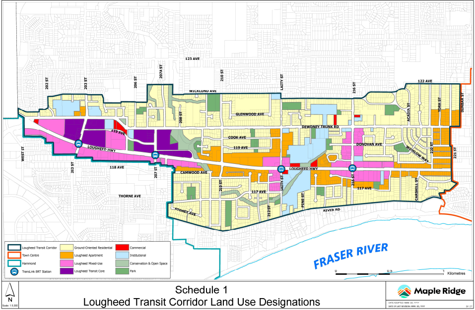
Land Use
Obviously an important part of the plan should be the active transportation infrastructure. However, much remains uncertain about the specifics and timelines for east-west cycling corridors:
- Lougheed Highway: for convenient and direct commuter cycling, part of TransLink’s Major Bike Network, and the desired location for a future Cycle Highway.
It’s not clear what type of active transportation infrastructure will be built (multi-use paths or bike lanes and sidewalks) as it is Ministry of Transportation and Transit’s jurisdiction and TransLink is also involved as it’s part of TransLink’s Major Bike Network. The LTCAP calls for “new active transportation infrastructure”. Completion will for a good part depend on re-development and will likely take decades. - Dewdney Trunk Road: the plan here is also for “new active transportation infrastructure” (HUB Cycling has been told uni-directional bike lanes), mostly through re-development. This exploration is very much in its infancy and if it’s indeed going to happen, this is a very, very long-term plan.
- West Ridge Greenway: between Lougheed and Dewdney, from 221 St. to 203 St.
The different road cross-sections that are proposed all include a multi-use path on one side and a wide sidewalk on the other side of the street, including a wide boulevard on both sides. Parking will be on both or one side, or none at all (e.g. through the Cemetery). The completion of this separated infrastructure also depends on re-development and will take many, many years. As an interim solution the City will explore implementing a neighbourhood bikeway and traffic calming.
Here is an image showing the location of the West Ridge Greenway:
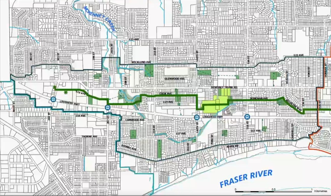
West Ridge Greenway location (in green)
And here is an image showing the selected designs for the Greenway, all with a multi-use path on one side and a sidewalk on the other:
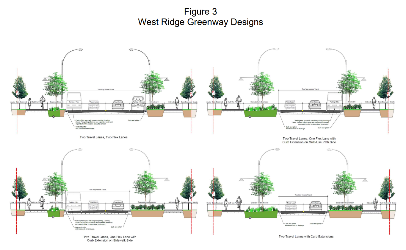
West Ridge Greenway road cross-sections
Given that both Lougheed Hwy and Dewdney Trunk Road are unlikely to feature connected cycling infrastructure within the next few decades, HUB Cycling Local Committee sees the West Ridge Greenway as our best option for short- (up to 10 years) and medium-term (10-20 years) connected cycling facilities. This corridor will remain very important for active transportation in the long-term as well, as it’s meant to be a low-traffic, low stress option, providing access to residences, greenspace and services.
The HUB Local Committee therefore ask the City that a high quality connected east-west cycling route along the West Ridge Greenway be given high priority by the City, to give present and future residents along the Lougheed Transit Corridor and beyond a safe, connected option for biking and rolling in the shortest possible time frame.
Our ask for the West Ridge Greenway
Short term:
The relatively low-cost short-term solution is implementing a low-speed neighbourhood bikeway along the existing roadways, and to fix gaps such as the Maple Ridge Cemetery and the McKenney Creek area.
Long term:
Plan for future expected high usage now and prioritize pedestrian and cyclist safety and comfort to support and encourage modal shift:
- Where possible, preserve low-traffic neighbourhood bikeways through traffic diversion;
- Separated sidewalks and uni-directional bike paths on both sides (not a more conflict-prone multi-use path on one side of the street);
- Continuous paths (elevated through driveways and intersections) to improve safety and comfort for vulnerable users;
Lougheed Highway and Dewdney Trunk Road:
As to Lougheed Highway and Dewdney Trunk Road, the HUB Local Committee will continue to work with the relevant levels of jurisdiction to achieve the best possible solution. For this densifying area, we are asking for protected facilities, with separated sidewalks and cycling/micromobility infrastructure to serve increasing numbers of people walking, cycling and rolling of all ages and abilities. What is decided now, will be built to serve the community for at least the next 50 years and likely beyond, as it’s much harder to make changes once the area has been re-developed.
The HUB Local Committee sent this more detailed letter to Mayor and Council in early December. We have not received a response.
What you can do:
Submit your written comments to Mayor and Council at mayorcouncilandcao@mapleridge.ca, with cc to: clerks@mapleridge.ca, prior to Public Hearing on Jan. 20. Please include these important points in your comments:
- high quality active transportation, i.e. people walking separated from people using bikes, e-bikes, e-scooters and other faster micromobility options;
- uni-directional cycling on both sides of the street (which puts us where drivers expect us to be);
- continuous pathways, i.e. elevated through driveways and intersections to improve safety for vulnerable users (this will help slow down motor vehicles exactly where they cross active transportation infrastructure);
- green paint in conflict zones to improve safety for people cycling;
- ensure that protected active transportation facilities are built all at once along complete segments of the Greenway, Lougheed Hwy and Dewdney Trunk Road, rather than hopscotch as re-development occurs, so that the infrastructure is actually usable.
Example of continuous pathway (or raised crossing) in Nanaimo:
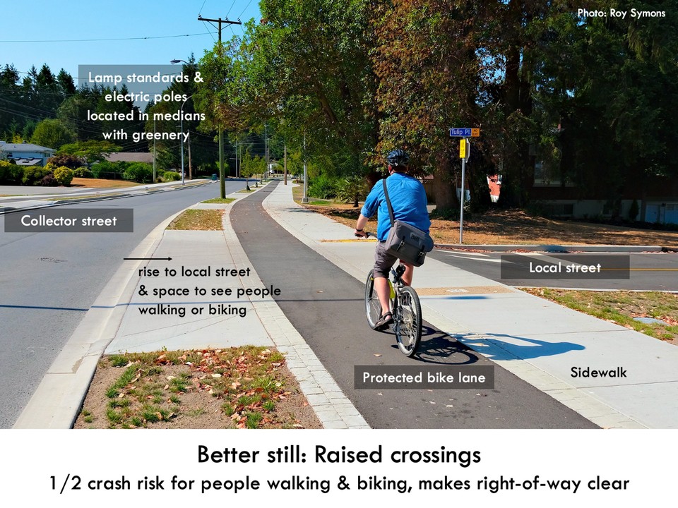
Nanaimo raised crossing
Speak at the Public Hearing in Council Chambers at City Hall on January 20, 7 pm. You can do so in person or virtually on Zoom. At the Public Hearing we suggest you bring up any of the points above.
Attend the Public Hearing to show your support.
Thank you for your help to create a better city for all!


