(Photo by Janet Dwillies)
Rides in the Ridge Meadows area suggested by the local HUB Committee
These rides have been crafted by HUB Cycling Maple Ridge/Pitt Meadows committee members. We’re on our bikes very often, and we know lots of great places to take them!
Maple Ridge 101
This shows off some bike routes for getting around Maple Ridge. We call it “Maple Ridge 101” as it uses some of the city’s most-used paths and goes near a lot of popular destinations.
About 15 km
Beginner
Downloadable maps: PDF | GPX

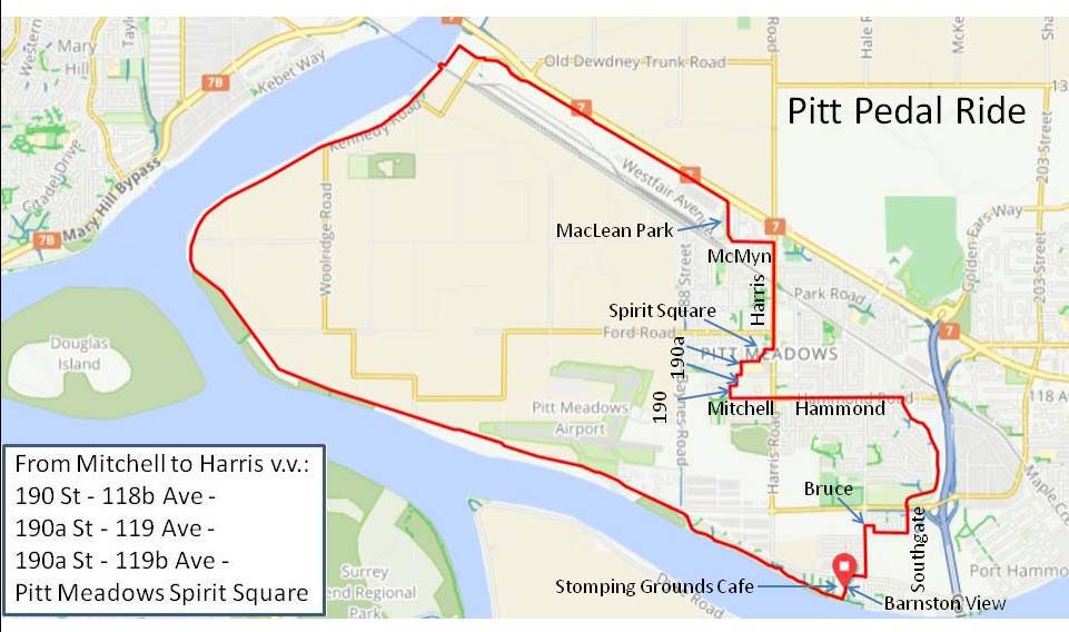
Pitt Pedal
This highlights routes around Pitt Meadows, with city and country paths for a route that surrounds nearly all of the city.
20 km
Beginner
Downloadable maps: PDF | GPX
East Side Ride
Explore bike routes between downtown Maple Ridge and neighbourhoods to the east.
20 km
Beginner
Downloadable maps: PDF | GPX
Update: As of March 2021, the pedestrian path connecting Burnett and 228 St. has been closed off. Please use the sidewalk on Lougheed Highway.

Whonnock Lake Ride
A nice ride around the Whonnock Lake area on country roads and a trail.
13 km
Beginner
Downloadable maps: PDF | GPX

Reg Franklin Park route
A nice ride with lots of variety. You’ll explore some of Maple Ridge’s quieter neighbourhoods and streets as well as the off-road pathway along Abernethy Way. The route leads you through some lovely neighbourhood parks.
13 km loop
Beginner
Downloadable maps: PDF | GPX

Jerry Sulina to Neaves Road
Start at Jerry Sulina Park and ride through the cranberry and blueberry fields to Neaves Road. See beautiful vistas of the mountains and fields.
12.5 km there and back
Beginner
Downloadable maps: PDF | GPX

Jerry Sulina to Silver Bridge
Start at Jerry Sulina Park and ride to Silver Bridge. This ride can also be started at Silver Bridge and ride to Jerry Sulina Park. Follow the South Alouette River and enjoy beautiful views of the mountains. Be sure to watch for eagles and herons along the way.
12 km there and back
Beginner
Downloadable maps: PDF | GPX

216th to Equestrian Centre
Park at the end of 216th and enjoy a short ride through cranberry and blueberry fields around to the Equestrian Centre. Watch for horses!
6 km
Beginner
Downloadable maps: PDF | GPX

216th to Neaves Road
Park at the end of 216th and enjoy a short ride through cranberry and blueberry fields enjoying wide open views of the fields and mountains.
6.7 km there and back
Beginner
Downloadable maps: PDF | GPX
Jerry Sulina to Pitt River Bridge
Start at Jerry Sulina Park and follow the South Alouette River to the marina and then along the Pitt River to the Pitt River Bridge. Enjoy beautiful views of the mountains and fields. Be sure to watch for eagles and herons along the way. There are many benches along this route to stop and rest and enjoy the views.
19.6 km there and back
Advanced
Downloadable maps: PDF | GPX

Jerry Sulina to Osprey Village
Pack a lunch for this ride! Start at Jerry Sulina Park, and ride along the dykes to Osprey Village, have your lunch in the park or visit the coffee shop or ice cream parlour. You can also start at Osprey Village and ride the dykes to Jerry Sulina Park!
41.2 km there and back
Advanced
Downloadable maps: PDF | GPX

Downtown Maple Ridge to Osprey Village
Pack a lunch for this ride! Start in downtown Maple Ridge, ride along relatively quiet streets to Osprey Village, have your lunch in the park or visit the coffee shop or ice cream parlour. See Comfortable Bike Route to Osprey Village from Downtown Maple Ridge for detailed instructions.
Under 20 km there and back
Beginner
Downloadable maps: GPX

Dyke Tour
Starting at Jerry Sulina Park, this ride will take you along the dykes of the South Alouette River, the North Alouette River and the dyke along the Pitt River. Enjoy views of the mountains and rivers and be sure to watch for eagles and herons! There are plenty of benches along the route to rest and have a snack and enjoy the views.
Shorter ride (22.6 km, Advanced):
Downloadable maps: PDF | GPX

Longer ride (33 km , Advanced)
Downloadable maps: PDF | GPX

Let’s Go Biking! Rides
These are local rides from the wonderful site https://www.letsgobiking.net; some of them are also in the book of the same name.
Blue Heron Loop
Framed by the mountains in the north and circling blueberry fields. There’s some fun singletrack and rocky sections on this one so take your mountain bike.
10-20 km
Advanced
https://www.letsgobiking.net/advanced/120-blue-heron-loop-maple-ridge/
Cranberry Trail
Multiple routes. You’ll see cranberry fields, brilliant blueberry bushes, pumpkin patches, three rivers, and an airport.
10-20 km
Beginner
https://www.letsgobiking.net/beginner/cranberry-trail-maple-ridge/
Ridge Meadows Circle
20-30 km
Advanced
The full circle is mostly on dyke trails and quiet shared roads. You’ll see cranberry fields, three rivers, an airport, pumpkin patches; and might spot eagles, herons, and horses along the way.
https://www.letsgobiking.net/advanced/30-maple-ridge-circle/
Three Bridges
Enjoy three bridges, three parks, and three greenways on this loop around the Fraser River. Ride over the Port Mann Bridge, through Surrey, over the Golden Ears Bridge, along the Pitt River Greenway, and the Poco Trail.
Over 40 km
Advanced
https://www.letsgobiking.net/advanced/115-three-bridges-port-mann-golden-ears/