Pitt Meadows’s Vision of Comfortable-For-All Bike Network
At a recent council meeting, the city of Pitt Meadows approved its 2023 Active Transportation Plan (ATP).
Active transportation refers to any mode of travelling using one’s own power to get from one place to another. The most common forms are walking and cycling, and others include scootering and skateboarding (human or electric-powered), in-line skating or using a wheelchair. The new ATP replaces the 2012 Pedestrian and Cycling Master Plan to reflect evolving guidance on the design and planning for active modes.
The ATP fits into and forms an integral part of the overall Transportation Plan which deals with vehicle, transit and other modes of powered transportation.
The ATP is a comprehensive document that clearly outlines the city’s vision for the future active transportation network. Notably, it articulates in detail how this vision will be transformed into reality. This includes identifying existing problems, defining objectives, specifying the target user groups for the network, determining the types of facilities to be constructed and their locations, establishing relative priorities for each project, setting timeframes, and estimating the costs associated with each individual project.
In this article we will go over the ATP document and delve into the details as it relates to cycling. As this goes to press, the final version of the ATP is yet to be released. However, given that Council has already approved virtually the entirety of the key recommendations laid out in the draft ATP, the analyses presented here should remain relevant when the final version of the ATP becomes publicly accessible.
TL;DR
For those who are time and/or attention-span challenged, below are the plan’s highlights.
- The plan lays the groundwork by defining types of cycling facilities under consideration and those it intends to build for the majority of its residents.
- The plan’s specific goals and objectives:
- connect key destinations in the city
- get rid of door-zone bike lanes
- add protected bike lanes in key routes
- create neighbourhood bikeways with enforced traffic calming
- It identifies specific projects; the top five in descending priorities:
- Harris Road Complete Street Retrofit
- Harris Road Complete Street Full Construction
- Hammond Road Protected Bike Lanes
- Parkside Trail Multi-Use Pathway
- Secondary School Neighbourhood Bikeway
Definitions and Terminology
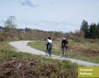
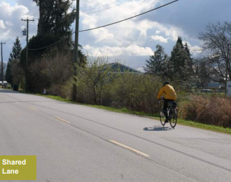
The ATP sets the stage by describing a set of terminology upon which the subsequent discussions are based. To help readers visualize and have a feel of what it would be like riding on one of such facilities, each facility type comes with a brief description and an image.
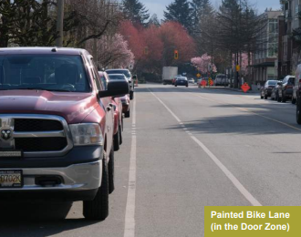
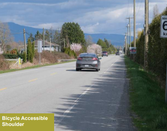
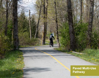
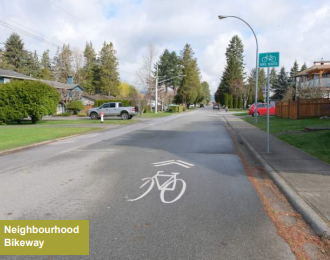
In a similar vein, the ATP delineates the current state of the Pitt Meadows bicycle network based on the rider’s comfort level. For those who are ‘strong and fearless’ riders, the bike network appears quite comprehensive, as virtually all existing roads are accessible to them. Conversely, for those who do not feel at ease riding alongside fast-moving vehicles, the network significantly diminishes. Employing the terminology jointly devised between HUB and Translink as part of the State of Cycling project, the existing Pitt Meadows bike network can be characterized as follows, contingent upon an individual’s comfort level.
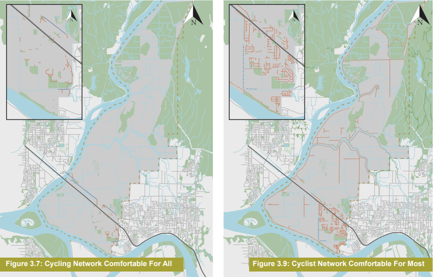
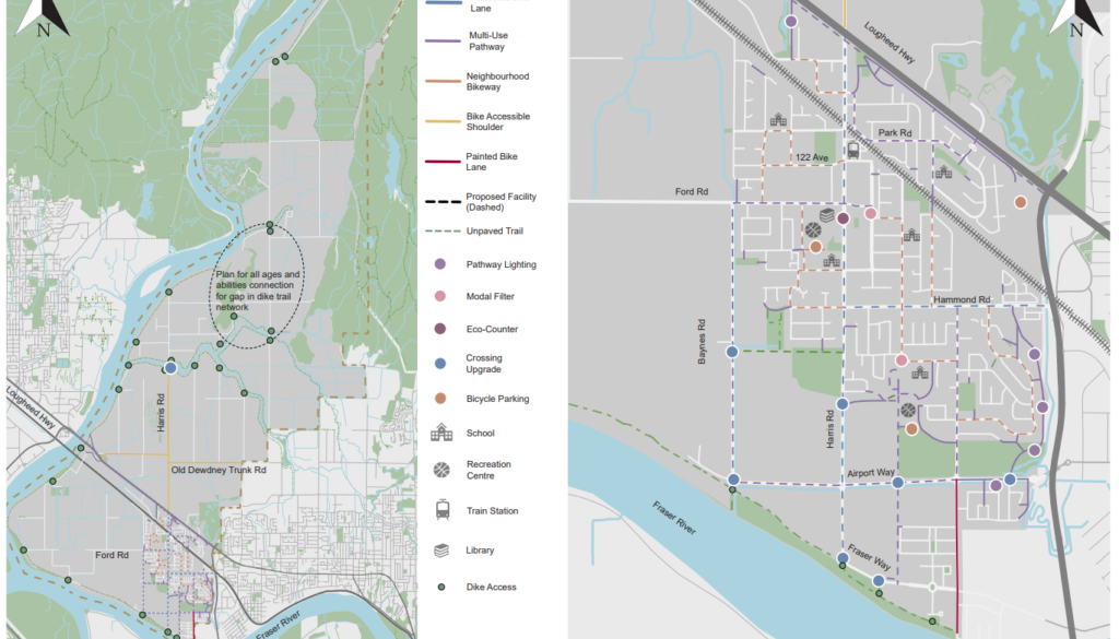
Pitt Meadow’s bicycle network comfortable for all (left) and comfortable for most (right)

Pitt Meadow’s bicycle network comfortable for some (left) and comfortable for few (right)
As evident from the map, the cycling network that accommodates all comfort levels doesn’t resemble much of a network at all. With the exception of the dike trail, which serves primarily recreational purposes, the vast majority of Pitt Meadows, including the downtown and Highland core area, is essentially inaccessible for cyclists.
Goals and Objectives
With a broad vision of building an all ages and abilities active transportation network and connecting all neighbourhoods and key amenities in the urban core by 2040, the ATP identifies a set of objectives, including:
- Connect key destinations in the city – connect major transit destinations, schools, community centres and commercial centers by active transportation.
- Upgrade door zone bike lanes – remove and replace door zone bike lanes with safer configurations.
- Add protected mobility lanes on key routes – uni-directional lanes are preferred over bi-directional lanes.
- Create neighbourhood bikeways with enhanced traffic calming – 30 km/h speed limit on identified routes, along with potential additional traffic calming to physically enforce the speed.
- Make routes accessible after dark and in all weather – adequate lighting and paved surfaces to be considered for routes intended for all ages and abilities.
Key Infrastructure Recommendations
Harris Road complete street protected bike lanes
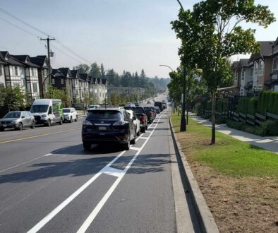
Harris Road is the primary north-south corridor through the urban core and provides direct access to some of the primary commercial and community amenities in the City. It is the most direct route for people traveling by any mode of transportation, including active modes. As such, uni-directional protected bike lanes are recommended along the approximately 2.2 km stretch. Coordination will be required with the underpass project with the Vancouver Port Fraser Authority, CP Rail and the Lougheed Highway/Harris Road upgrade by the provincial Ministry of Transportation.
 Hammond protected bike lanes
Hammond Road protected bike lanes
As one of the primary east-west corridors in the city connecting to Maple Ridge, it has painted bike lanes in the door zone of parked vehicles for approximately half of the corridor on both sides west of Bronson Road. It is recommended that Hammond Road be upgraded to protected bike lanes. Two options of bi-directional versus uni-directional protected bike lanes are outlined with details on how to address the reduced width east of Bronson Road. Facility length: 3 km.

Hammond Road protected bike lanes
Neighbourhood Bikeways
Neighbourhood bikeways facilitate trips from neighbourhoods to major transit destinations, schools, community centres and commercial centers by active transportation. To make these bikeways accessible and comfortable for all ages and abilities, some of the following measures will be applied:
- reclassification and downgrading the street to a minor collector
- 30 km/h posted speed
- speed cushions to enforce the posted speed
- sharrow pavement markings
- removing the centre line
Four neighbourhood bikeways are identified:
Secondary School Neighbourhood Bikeway
This neighbourhood bikeway would facilitate trips to Pitt Meadows Secondary School as well as provide connections to the Hammond Road protected bike lanes and the Bonson Road and Wildwood Trail multi-use pathways. The neighbourhood bikeway includes sections of Blakely Road, 116b Avenue, and Wildwood Crescent.

Secondary school neighbourhood bikeway
Highland Park Neighbourhood Bikeway
This neighbourhood bikeway would facilitate trips to Highland Park Elementary School, MacLean Park, and the nearby West Coast Express Pitt Meadows Station. It would provide connections to the Harris Road protected bike lanes, as well as the MacLean Park, Park Road, Ford Road, and 193 Street / 122a Avenue multi-use pathways. The neighbourhood bikeway includes sections of McMyn Road, 191 Street, 124 Avenue, 122 Avenue, 190 Street, Advent Road, and 189a Street.
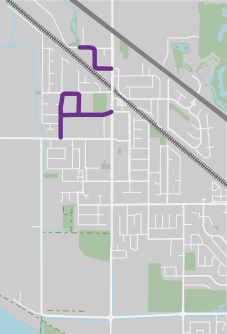
Highland Park Neighbourhood Bikeway
Recreation Centre Neighbourhood Bikeway
This neighbourhood bikeway would facilitate trips to the Pitt Meadows Elementary School and Recreation Centre, as well as provide connections to the Harris Road and Hammond Road protected bike lanes, and the Ford Road multi-use pathway. The neighbourhood bikeway includes sections of 190 Street, 119b Avenue, 119 Avenue, 190a Street, 118b Avenue, 190 Street, and Mitchell Road.

Creation Centre neighbourhood bikeway
Navie Jones Neighbourhood Bikeway
This neighbourhood bikeway would facilitate trips to Davie Jones Elementary School and provide connections to the Hammond Road and the 193 Avenue / 122a Avenue protected bike lanes, the Bonson Road multi-use pathway, and the Secondary School neighbourhood bikeway. The neighbourhood bikeway includes sections of 120b Avenue, Blakely Road, and Bonson Road.

Navie Jones neighbourhood bikeway
Multi-use Pathways (MUPs)
Although separated bike lanes are generally preferred, MUPs are considered in areas where space is constrained and cyclist/pedestrian volumes are anticipated to be lower.
8 MUPs are identified:
Bonson Road Multi-use Pathway
Bonson Road is currently posted at either 30 km/h or 50 km/h and people riding bicycles must share the road with motor vehicles. The recommended MUP – on the west side – would extend from 116b Ave to the Airport Way, and connect the proposed protected bike lanes on Hammond Road with the proposed neighbourhood bikeway on 116b Avenue, Bonson Park, and the Arena Complex, and planned bike lanes to Osprey Village.
Bonson Road multi-use path
Ford Road Multi-use Pathway
Ford Road currently features painted bike lanes on both sides of the roadway that are within the door zone of adjacent parking lanes. The recommended MUP – on the south side – would replace the existing facility and extend from Baynes Road to 193 Street, and provide a connection between Baynes Road pathway and proposed Davie Jones Neighbourhood Bikeway.

Ford Road multi-use path
Airport Way Multi-use Pathway
This proposed new paved MUP between Bonson Road and Baynes Road would connect the existing Trans Canada Trail multi-use pathway on Airport Way (between Bonson Road and Alouette Place) and the Wildwood Trail with the proposed Baynes Road pathway.

Airport Way multi-use path
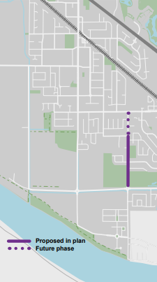
Parkside Trail Multi-use Pathway
This proposed new paved MUP would replace the existing gravel trail and connect the planned multi-use Pathway through the adjacent development to Harris Road.

Parkside Trail multi-use path
Lougheed Highway Multi-use Patway (East of Harris Road)
This paved MUP would connect the existing multi-use pathway east of Harris Road Park with the intersection of Harris Road and Lougheed Highway, providing a direct route to the proposed pathway west of this intersection and the proposed Harris Road protected bike lanes. This pathway would also connect to a future multi-use pathway along Park Road, as well as both the existing Harris Road bike accessible shoulder north of Lougheed Highway and provide a direct connection to RapidBus transit stops at this intersection.
This project would need to work with the provincial Ministry of Transportation which is planning a major intersection upgrade there.

Lougheed Highway multi-use path west of Harris Road
Lougheed Highway Multi-use Pathway (West of Harris Road)
This new paved MUP would complete the missing link in the Lougheed Highway by connecting the existing multi-use pathway west of MacLean Park with the intersection of Harris Road and Lougheed Highway, and providing a direct route to the both proposed pathway east of this intersection and the proposed Harris Road protected bike lanes. This pathway would also connect to the existing Harris Road bike accessible shoulder north of Lougheed Highway and provide a direct connection to RapidBus transit stops at this intersection.
This project would need to work with the provincial Ministry of Transportation.

Lougheed Highway multi-use path west of Harris Road
Baynes Road Multi-use Pathway
A paved MUP between Ford Road and Airport Way in place of the existing gravel pathway would provide a more comfortable connection to the airport, for recreation and provides access to the Airport Trail and Dike Trail system.

Baynes Road multi-use path
Park Road Multi-use Pathway
As a collector street to carry traffic between Lougheed Highway and Harris Road, this street is not suitable as a neighbourhood bikeway. The proposed facility would be either MUP or protected bike lane. It would connect the existing pathway along Lougheed Highway to the proposed Harris Road protected bike lanes and the existing 124 Avenue neighbourhood bikeway west of Harris Road. This proposed pathway would also extend on Bonson Road, connecting Park Road with Edith McDermott Elementary, the pedestrian and bicycle overpass further south, and by extension the Bonson Road neighbourhood bikeway.

Park Road multi-use path
Below is what the Pitt Meadows bicycle network looks like when the proposed infrastructures are put in place.

Proposed Pitt Meadows bicycle network. Dotted lines are proposed facilities.
Priorities
The ATP also assigns priorities to the infrastructure line items identified in the above recommendations. Keep in mind, though, that a higher priority does not automatically translate to said item being implemented ahead of the items below it. Much depends on funding and grant availability and other factors which might influence the order in which these projects get executed. That said, here are the priorities in descending order.
- Harris Road Complete Street Retrofit
- Harris Road Complete Street Full Construction
- Hammond Road Protected Bike Lanes
- Parkside Trail Multi-Use Pathway
- Secondary School Neighbourhood Bikeway
- Highland Park Neighbourhood Bikeway
- Rec Centre Neighbourhood Bikeway
- Davie Jones Neighbourhood Bikeway
- Bonson Road Multi-Use Pathway
- Baynes Road Multi-Use Pathway
- Park Road Multi-Use Pathway
- Ford Road Multi-Use Pathway
Closing Thoughts
The city of Pitt Meadows acknowledges that the current bicycle infrastructure caters primarily to strong and fearless cyclists. To promote active transportation among the broader population, there’s a recognized need for facilities that are comfortable for most, if not all residents. According to the vision and the specific proposals outlined in the ATP, the city envisions a well-connected bike network, at least in the core area, which will be accessible to the majority of its residents once the plan is fully implemented.
Caveat Emptor: Just because something is documented doesn’t guarantee implementation. Given the ATP’s projection of a 20 to 40-year timeline for full realization, much can change during the intervening years. This includes potential shifts in political will and other prevailing priorities. Naturally, funding and grant opportunities consistently play a decisive role in all infrastructure projects.
With that said, we find great encouragement in the city’s commitment to active transportation and their meticulous efforts in delineating concrete actions to bring this vision to fruition. We eagerly anticipate the implementation of these specific projects, transforming them from plans into tangible realities.
